

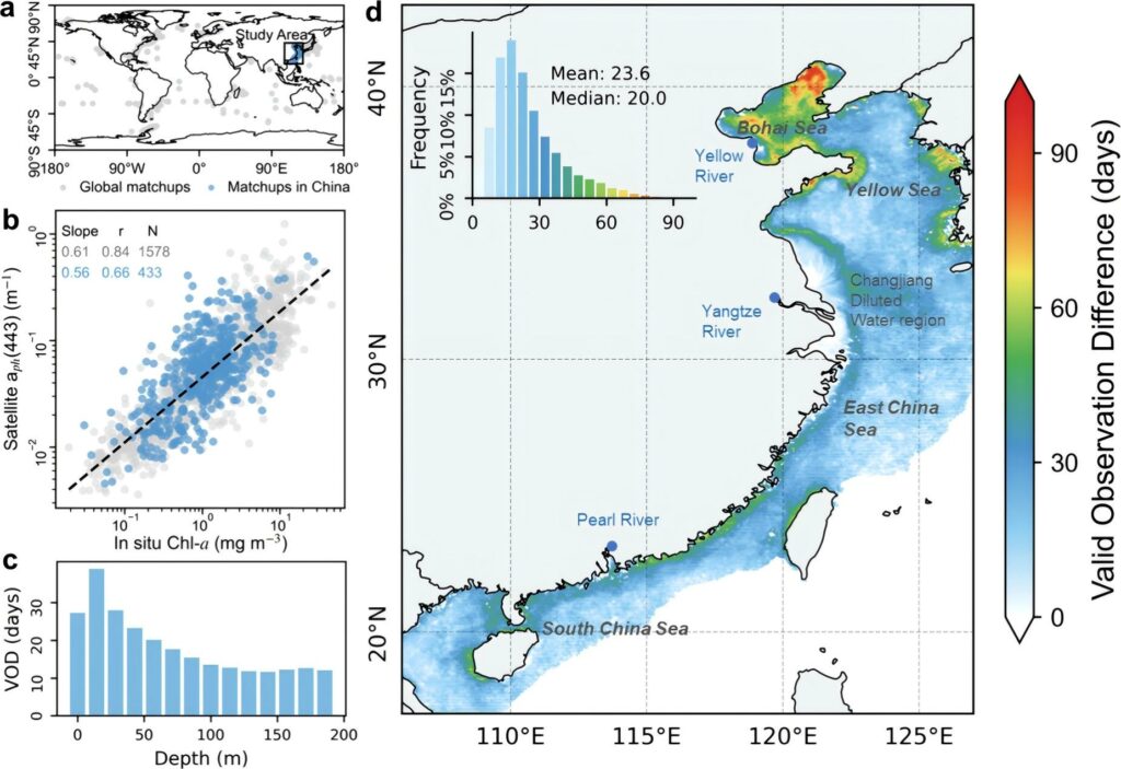
Basic descriptions This dataset covers two decades (2003-2022) of phytoplankton absorption coefficients at 443nm (aph(443)) in Chinese coastal waters (water depth < 200m). The data were derived from Remote Sensing Reflectance (Rrs) using newly enhanced coastal aerosol models in combination with NASA’s standard atmospheric correction methods. The resulting aph(443) values were then retrieved through the
25
Mar
Mar
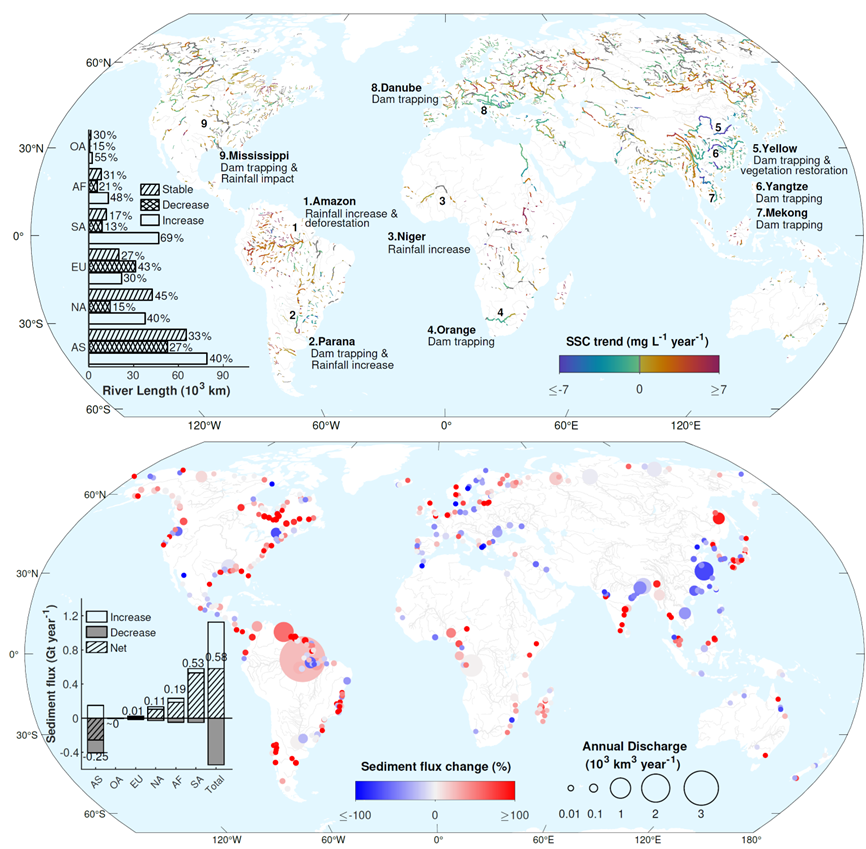
Basic descriptions The Global fluvial Sediment Dataset (GSED) provides suspended sediment concentration data at the reach scale worldwide from 1985 to 2020, covering 6,383 river segments with channel widths exceeding 120 meters. This dataset is constructed using Landsat-4/5/7 satellite imagery based on weighted multi-band ratios model, delivering monthly averaged suspended sediment concentration (mg/L) for each
25
Mar
Mar
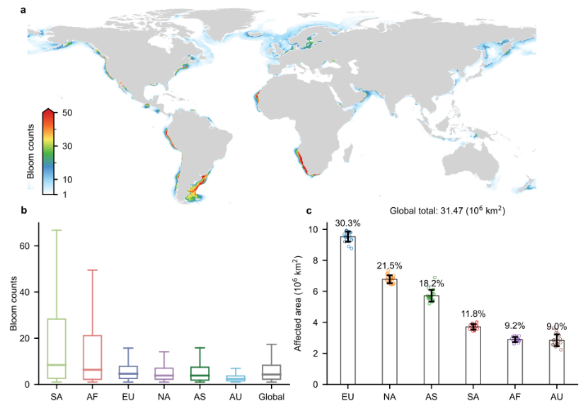
Basic description We developed a satellite-based dataset of global freshwater lake algal blooms from 2003 to 2022, covering 1,956 large lakes and reservoirs , each larger than 50 km². The dataset was derived from global daily observations at 1-km resolution from the MODIS onboard NASA’s Aqua satellite, using all 0.8 million images acquired between 2003
20
Dec
Dec
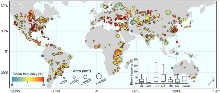
Basic descriptions The Global Coastal Algal Bloom Dataset is derived from daily MODIS satellite images with a resolution of 1 km, totaling 0.76 million images globally, spanning the period from 2003 to 2020. It captures the occurrences of coastal blooms for 126 out of 153 ocean-bordering countries worldwide. Compared to prior global coastal phytoplankton datasets
13
Dec
Dec
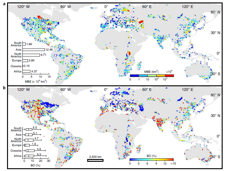
Basic descriptions This dataset provides maximum bloom extent (MBE, in km2) and median bloom occurrence (BO, in %) for 21,878 freshwater lakes worldwide in the entire period (1980s-2010s) and three sub-periods (1980–1990s, 2000s and 2010s), which was generated using Landsat satellite observation between 1982 to 2019. Data download The shapefiles are publicly available at this lab
12
Dec
Dec
Basic descriptions The “China lake algal bloom” dataset describes the algal bloom conditions in 103 Chinese lakes affected by algal blooms over the past two decades (2003 to 2020). It is a dataset that includes annual scale data of algal bloom occurrence (BO), onset time (Onset), potential occurrence period (POP), and maximum bloom extent (MBE). The dataset was compiled